No edit summary |
(added a background information section with info from STE) Tag: sourceedit |
||
| (6 intermediate revisions by 5 users not shown) | |||
| Line 1: | Line 1: | ||
| + | {{at|xx}} |
||
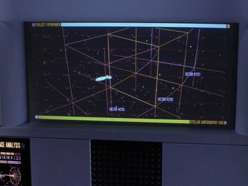
[[File:Pathfinder sector projections.jpg|thumb|A map containing [[Sector 41751|Sectors 41751]], [[Sector 41752|41752]], and [[Sector 41753|41753]]]] |
[[File:Pathfinder sector projections.jpg|thumb|A map containing [[Sector 41751|Sectors 41751]], [[Sector 41752|41752]], and [[Sector 41753|41753]]]] |
||
| + | In [[cartography]] a '''sector''' was an area in physical space. |
||
| ⚫ | In [[stellar cartography]] a |
||
| + | The surface of [[planet]]ary bodies were gridded into sectors. ({{film|3}}; {{film|12}}) |
||
| − | {{bginfo|According to the ''[[Star Trek Encyclopedia]]'', a sector is a volume of space approximately twenty light years across. A typical sector in Federation space would contain about six to ten star systems, although sectors toward the [[galactic core]] would often contain many more.}} |
||
| + | |||
| ⚫ | In [[stellar cartography]], a sector, which was referred to as a '''star sector''' or '''space sector''', was a gridded region within the [[Milky Way Galaxy]]. Sectors were composed of an area and volume encompassing several [[light year]]s and typically contained several [[star system]]s. A group of sectors was called a [[sector block]], which was located in a [[quadrant]]. The sector system and their numbering was used by [[United Earth]], [[Vulcan]]s, and other spacefaring races at least by the [[22nd century]]. In [[2369]], the extragalactic space was not divided into sectors, and ships that were sent on deep space cartography missions were listed as being in extragalactic space. ({{TNG|Aquiel}}; {{ENT|Broken Bow|Detained}}; {{film|12}}) |
||
==Size and range == |
==Size and range == |
||
| Line 10: | Line 13: | ||
When the {{USS|Enterprise|NCC-1701}} was probed while ''en route'' through an unfamiliar sector of space in [[2269]], the crew was able to determine the source as being from a planet in the [[Taurean system]], a system located twenty light years away, at the extreme edge of their sector. ({{TAS|The Lorelei Signal}}) |
When the {{USS|Enterprise|NCC-1701}} was probed while ''en route'' through an unfamiliar sector of space in [[2269]], the crew was able to determine the source as being from a planet in the [[Taurean system]], a system located twenty light years away, at the extreme edge of their sector. ({{TAS|The Lorelei Signal}}) |
||
| − | In preparation for [[Operation Lovely Angel]], the {{USS|Enterprise|NCC-1701-D|-D}} |
+ | In preparation for [[Operation Lovely Angel]], the {{USS|Enterprise|NCC-1701-D|-D}} [[scan]]ned all sectors located within three light years of the [[Oneamisu sector]]. ({{TNG|Peak Performance}}) |
| − | A {{ |
+ | A {{class|Galaxy}} ship was capable of scanning a radius of ten light years at a time, which allowed the ship to effectively scan one sector per day. ({{TNG|The Wounded}}) |
While ''en route'' to the [[planet]] [[Barisa Prime]] in [[2371]], [[Captain]] [[Benjamin Sisko]] noted that the closest ship in that sector, the {{USS|Ulysses}}, which was exploring the [[Helaspont Nebula]], was located twenty [[hour]]s away at [[maximum warp]]. ({{DS9|The Adversary}}) |
While ''en route'' to the [[planet]] [[Barisa Prime]] in [[2371]], [[Captain]] [[Benjamin Sisko]] noted that the closest ship in that sector, the {{USS|Ulysses}}, which was exploring the [[Helaspont Nebula]], was located twenty [[hour]]s away at [[maximum warp]]. ({{DS9|The Adversary}}) |
||
| Line 22: | Line 25: | ||
==Composition== |
==Composition== |
||
[[File:Romulan Neutral Zone map.jpg|thumb|A map of [[Sector Z-6]]]] |
[[File:Romulan Neutral Zone map.jpg|thumb|A map of [[Sector Z-6]]]] |
||
| − | [[Sector Z-6]] |
+ | [[Sector Z-6]] encompassed both Federation and [[Romulan Empire|Romulan]] space, and during the [[23rd century]], included seven [[Earth Outpost Station]]s, the [[Romulan Neutral Zone]], and [[Romulus]] and [[Romii]]. ({{TOS|Balance of Terror}}) |
The sector containing the [[Murasaki Effect]] contained at least four complete solar systems. ({{TOS|The Galileo Seven}}) |
The sector containing the [[Murasaki Effect]] contained at least four complete solar systems. ({{TOS|The Galileo Seven}}) |
||
| Line 28: | Line 31: | ||
The sector containing the planet [[Iconia]] contained three systems whose inhabitants had several cultural similarities with the [[Iconian]]s. ({{TNG|Contagion}}) |
The sector containing the planet [[Iconia]] contained three systems whose inhabitants had several cultural similarities with the [[Iconian]]s. ({{TNG|Contagion}}) |
||
| − | The sector |
+ | The sector in which the ''Enterprise''-D intercepted the [[class 8 probe]] occupied by [[Ambassador]] [[K'Ehleyr]] was said to contain very little, yet included four [[colony|colonies]] and nine [[outpost]]s throughout. A nearby sector that was threatened by the [[Klingon Empire|Klingon]] [[sleeper ship]] {{IKS|T'Ong}} contained thirteen [[Federation]] colonies. ({{TNG|The Emissary}}) |
When the [[Federation shuttlecraft|shuttlecraft]] ''[[Cochrane (shuttlecraft)|Cochrane]]'' achieved [[warp 10]], it collected data describing "literally every cubic centimeter" of the sector they were in – an amount of information exceeding five billion [[gigaquad]]s. ({{VOY|Threshold}}) |
When the [[Federation shuttlecraft|shuttlecraft]] ''[[Cochrane (shuttlecraft)|Cochrane]]'' achieved [[warp 10]], it collected data describing "literally every cubic centimeter" of the sector they were in – an amount of information exceeding five billion [[gigaquad]]s. ({{VOY|Threshold}}) |
||
==Naming== |
==Naming== |
||
| − | Most sectors |
+ | Most sectors were numbered, and in some cases, named after an important star system in that sector. In [[Federation]] nomenclature, the [[Sol system]] and [[Earth]] were located in [[Sector 001]]. ({{TNG|The Best of Both Worlds}}) Others were named after a key [[star system]], such as the [[Mutara sector]]. ({{film|2}}) In other cases, they were given a designation consisting of both a name and number, such as [[Rhomboid Dronegar sector 006]]. ({{TNG|Samaritan Snare}}) |
==Subsector== |
==Subsector== |
||
| − | A subsector was a region of space smaller than a sector |
+ | A subsector was a region of space smaller than a sector and located within sectors. Subsectors were also numbered, for example [[Subsector 4534|Subsectors 4534]]-[[Subsector 4432|4432]] within [[sector 450]]/32450 ({{TNG|Conspiracy}} [[:File:USS Puget Sound USS Ganymede.jpg|''display graphic'']]) and [[Subsector 321|subsector ref 321]]-053 within [[sector 30]]-489. |
| + | The latter number, such as the 053 in subsector ref 321-053, was the angle at which the subsector was being viewed on screen. ({{TNG|The Most Toys}} ''display graphic'') |
||
| − | {{bginfo|To date, subsectors have only been mentioned in this episode.}} |
||
==List of sectors== |
==List of sectors== |
||
* See [[:Category:Sectors|List of sectors]] |
* See [[:Category:Sectors|List of sectors]] |
||
| + | ==Background Information== |
||
| + | The ''[[Star Trek Encyclopedia]]'' (3rd ed., p. 434) defined a sector as, <blockquote>"''In interstellar mapping, a volume of space approximately twenty [[light year|light-years]] across. A typical sector in Federation space will contain about 6 to 10 star systems, although sectors toward the [[galactic core]] will often contain many more. The [[Milky Way Galaxy]] is divided into hundreds of thousands of sectors, grouped into four quadrants. Sectors are usually numbered, although in common usage they are often named for a major star or planet located in that sector.''"</blockquote> |
||
| + | |||
| + | The ''Star Trek Encyclopedia'' (3rd ed., p. 434) authors additionally said,<blockquote>"''The numbering system for sectors had been inconsistently used (and sometimes interchanged with quadrants) during the show, especially in its early days. We assume that some sectors may retain older designations from previous mapping systems, much as present-day astronomers still use NGC and Messier catalog numbers.''"</blockquote> |
||
| + | |||
| + | [[bg:Сектор]] |
||
[[de:Sektor]] |
[[de:Sektor]] |
||
[[it:Settore]] |
[[it:Settore]] |
||
Revision as of 14:23, 26 February 2016
AT: "xx"
A map containing Sectors 41751, 41752, and 41753
In cartography a sector was an area in physical space.
The surface of planetary bodies were gridded into sectors. (Star Trek III: The Search for Spock; Star Trek Into Darkness)
In stellar cartography, a sector, which was referred to as a star sector or space sector, was a gridded region within the Milky Way Galaxy. Sectors were composed of an area and volume encompassing several light years and typically contained several star systems. A group of sectors was called a sector block, which was located in a quadrant. The sector system and their numbering was used by United Earth, Vulcans, and other spacefaring races at least by the 22nd century. In 2369, the extragalactic space was not divided into sectors, and ships that were sent on deep space cartography missions were listed as being in extragalactic space. (TNG: "Aquiel"; ENT: "Broken Bow", "Detained"; Star Trek Into Darkness)
Size and range
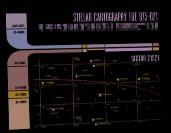
A map of Sector 21527
William T. Riker felt that the warp coil was perhaps one of the greatest advances in Humanity since the 22nd century, explaining that "before there was warp drive, Humans were confined to one sector of the galaxy." (TNG: "A Matter of Time")
When the USS Enterprise was probed while en route through an unfamiliar sector of space in 2269, the crew was able to determine the source as being from a planet in the Taurean system, a system located twenty light years away, at the extreme edge of their sector. (TAS: "The Lorelei Signal")
In preparation for Operation Lovely Angel, the USS Enterprise-D scanned all sectors located within three light years of the Oneamisu sector. (TNG: "Peak Performance")
A Galaxy-class ship was capable of scanning a radius of ten light years at a time, which allowed the ship to effectively scan one sector per day. (TNG: "The Wounded")
While en route to the planet Barisa Prime in 2371, Captain Benjamin Sisko noted that the closest ship in that sector, the USS Ulysses, which was exploring the Helaspont Nebula, was located twenty hours away at maximum warp. (DS9: "The Adversary")
The territory occupied by the Swarm species covered "a huge area of space" and included "hundreds of sectors." For the USS Voyager to go around that region, it would have taken over fifteen months at maximum warp. (VOY: "The Swarm")
Voyager's use of the graviton catapult "hurtled" the ship across thirty sectors of space in less than an hour, a journey that would have otherwise taken three years to accomplish. (VOY: "The Voyager Conspiracy")
Composition
A map of Sector Z-6
Sector Z-6 encompassed both Federation and Romulan space, and during the 23rd century, included seven Earth Outpost Stations, the Romulan Neutral Zone, and Romulus and Romii. (TOS: "Balance of Terror")
The sector containing the Murasaki Effect contained at least four complete solar systems. (TOS: "The Galileo Seven")
The sector containing the planet Iconia contained three systems whose inhabitants had several cultural similarities with the Iconians. (TNG: "Contagion")
The sector in which the Enterprise-D intercepted the class 8 probe occupied by Ambassador K'Ehleyr was said to contain very little, yet included four colonies and nine outposts throughout. A nearby sector that was threatened by the Klingon sleeper ship IKS T'Ong contained thirteen Federation colonies. (TNG: "The Emissary")
When the shuttlecraft Cochrane achieved warp 10, it collected data describing "literally every cubic centimeter" of the sector they were in – an amount of information exceeding five billion gigaquads. (VOY: "Threshold")
Naming
Most sectors were numbered, and in some cases, named after an important star system in that sector. In Federation nomenclature, the Sol system and Earth were located in Sector 001. (TNG: "The Best of Both Worlds") Others were named after a key star system, such as the Mutara sector. (Star Trek II: The Wrath of Khan) In other cases, they were given a designation consisting of both a name and number, such as Rhomboid Dronegar sector 006. (TNG: "Samaritan Snare")
Subsector
A subsector was a region of space smaller than a sector and located within sectors. Subsectors were also numbered, for example Subsectors 4534-4432 within sector 450/32450 (TNG: "Conspiracy" display graphic) and subsector ref 321-053 within sector 30-489.
The latter number, such as the 053 in subsector ref 321-053, was the angle at which the subsector was being viewed on screen. (TNG: "The Most Toys" display graphic)
List of sectors
- See List of sectors
Background Information
The Star Trek Encyclopedia (3rd ed., p. 434) defined a sector as,
"In interstellar mapping, a volume of space approximately twenty light-years across. A typical sector in Federation space will contain about 6 to 10 star systems, although sectors toward the galactic core will often contain many more. The Milky Way Galaxy is divided into hundreds of thousands of sectors, grouped into four quadrants. Sectors are usually numbered, although in common usage they are often named for a major star or planet located in that sector."
The Star Trek Encyclopedia (3rd ed., p. 434) authors additionally said,
"The numbering system for sectors had been inconsistently used (and sometimes interchanged with quadrants) during the show, especially in its early days. We assume that some sectors may retain older designations from previous mapping systems, much as present-day astronomers still use NGC and Messier catalog numbers."