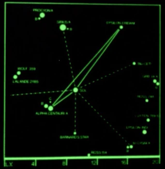
The location of Epsilon Eridani on a star chart
Epsilon Eridani was a star located approximately eleven light years from Sol
In 2364, the location of Epsilon Eridani was labeled in a star chart of a stellar neighborhood with Sol at the center. This chart was stored in the USS Enterprise-D library computer. Later that year, the chart was scanned by Outpost 63. (TNG: "The Naked Now", production art; TNG: "The Last Outpost")
The chart naming stars within twenty light years of Sol was drawn by Rick Sternbach for the Star Trek Spaceflight Chronology in the late 1970s. Found on page 77, this chart showed Earth commercial and exploration routes after the use of warp drive began. Epsilon Eridani was the terminus for two major commercial routes, Alpha Centauri-Epsilon Eridani and Sol-Epsilon Eridani.
According to Star Trek: Star Charts, Epsilon Eridani (Axanar) was located in or near Federation space, in the Beta Quadrant. The planet and homeworld of the Axanar, Axanar, was located in this system. This was a binary star system. Epsilon Eridani A was a K class star with a magnitude of +5, which was the same brightness as Sol. Epsilon Eridani B was K class. (Pg. 45, 60, "United Federation of Planets I")
External links
- Epsilon Eridani at Wikipedia
- Epsilon Eridani at the Internet Stellar Database
- Template:NCwiki