m (robot Adding: fr:Mer de Béring) |
No edit summary |
||
| Line 1: | Line 1: | ||
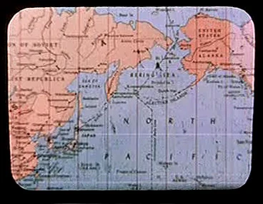
[[File:Earth map, 20th century, North Pacific.jpg|thumb|A map of Earth's [[Pacific Ocean]] showing the Bering Sea.]] |
[[File:Earth map, 20th century, North Pacific.jpg|thumb|A map of Earth's [[Pacific Ocean]] showing the Bering Sea.]] |
||
| − | The '''Bering Sea''' was a body of [[water]] on [[Earth]], lying between the [[United States of America]] and the [[Union of Soviet Socialist Republics]]. |
+ | The '''Bering Sea''' was a body of [[water]] on [[Earth]], lying between the [[United States of America]] and the [[Union of Soviet Socialist Republics]]. The [[International Date Line]] ran through the Bering Sea. Major islands of the sea include the [[Aleutian Islands]]. ({{TOS|The Cage}}) |
{{bginfo|This sea was identified on a political map of the North [[Pacific Ocean|Pacific]] region. This map was accessed from the {{USS|Enterprise|NCC-1701}} [[USS Enterprise (NCC-1701) library computer|library computer]] by the [[Talosian]]s in [[2254]].}} |
{{bginfo|This sea was identified on a political map of the North [[Pacific Ocean|Pacific]] region. This map was accessed from the {{USS|Enterprise|NCC-1701}} [[USS Enterprise (NCC-1701) library computer|library computer]] by the [[Talosian]]s in [[2254]].}} |
||
| − | In [[1986]], the [[humpback whale]]s [[George |
+ | In [[1986]], the [[humpback whale]]s [[George and Gracie]] were released back into the wild in the Bering Sea. They nearly fell victim to poachers before the men were scared off by the [[cloak|decloaking]] of a captured [[Klingon Bird-of-Prey]], dubbed {{HMS|Bounty}} by the [[officer]]s of the late [[starship]] {{USS|Enterprise|NCC-1701}}. ({{film|4}}) |
==External link== |
==External link== |
||
| − | * |
+ | *{{Wikipedia}} |
| ⚫ | |||
[[de:Beringstraße]] |
[[de:Beringstraße]] |
||
[[fr:Mer de Béring]] |
[[fr:Mer de Béring]] |
||
[[nl:Beringzee]] |
[[nl:Beringzee]] |
||
| ⚫ | |||
Revision as of 21:33, 9 February 2011
A map of Earth's Pacific Ocean showing the Bering Sea.
The Bering Sea was a body of water on Earth, lying between the United States of America and the Union of Soviet Socialist Republics. The International Date Line ran through the Bering Sea. Major islands of the sea include the Aleutian Islands. (TOS: "The Cage")
This sea was identified on a political map of the North Pacific region. This map was accessed from the USS Enterprise library computer by the Talosians in 2254.
In 1986, the humpback whales George and Gracie were released back into the wild in the Bering Sea. They nearly fell victim to poachers before the men were scared off by the decloaking of a captured Klingon Bird-of-Prey, dubbed HMS Bounty by the officers of the late starship USS Enterprise. (Star Trek IV: The Voyage Home)