m (-uncited note, see talk page, amended section to include reference to the glacier) |
m (cleanup, links, linkfixes) Tag: sourceedit |
||
| (4 intermediate revisions by 4 users not shown) | |||
| Line 1: | Line 1: | ||
| − | [[File:Borg sphere in the Arctic.jpg|thumb| |
+ | [[File:Borg sphere in the Arctic.jpg|thumb|Borg sphere debris in the Arctic Circle]] |
| ⚫ | |||
| ⚫ | |||
| ⚫ | The '''Arctic Circle''' was a line of latitude on [[Earth]] which marked the boundary between the [[North Pole]] |
||
| + | In the late [[17th century]], the Arctic Circle, located under the [[Kara Sea]], was labeled on a [[map]] of Earth. The label for this latitude was in [[Latin]] - "''Circulus Arcticus''". (''[[Star Trek: Enterprise]] opening credits'') |
||
| − | {{bginfo|This line of latitude was identified on a political map of the North [[Pacific Ocean|Pacific]] region. This map was accessed from the {{USS|Enterprise|NCC-1701}} [[USS Enterprise (NCC-1701) library computer|library computer]] by the [[Talosian]]s in [[2254]].}} |
||
| − | In [[2063]], the {{USS|Enterprise|NCC-1701-E|-E}} pursued a [[Borg sphere]] to Earth from the [[24th century]] through a Borg-created [[temporal vortex]]. |
+ | In [[2063]], the {{USS|Enterprise|NCC-1701-E|-E}} pursued a [[Borg sphere]] to Earth from the [[24th century]] through a Borg-created [[temporal vortex]]. The [[Borg]] had arrived to destroy the ''[[Phoenix]]'', [[Zefram Cochrane]]'s [[history|historic]] first [[warp]]-[[power]]ed vessel. The ''Enterprise''-E easily destroyed the sphere, though the [[Borg drone]]s escaped. ({{film|8}}) |
| − | [[2153|Nearly a hundred years later]], an [[Earth Sciences Institute]] team discovered the debris field and recovered two [[Borg |
+ | Unknown to the ''Enterprise''-E crew, much of the [[debris]] from the Borg sphere [[crash landing|landed]] in the Arctic Circle. [[2153|Nearly a hundred years later]], an [[Earth Sciences Institute]] [[Arctic Archaeology Team|team]] discovered the debris field and recovered two [[Unnamed Borg#Defrosted drones|Borg drones]] from beneath a [[glacier]]. The drones thawed and [[assimilation|assimilated]] the [[researcher]]s and [[Arctic One|their ship]]. ({{ENT|Regeneration}}) |
| + | == Background info == |
||
| − | [[20th century]]-era maps of the Arctic Circle, including the North Pole were stored in the {{USS|Enterprise|NCC-1701}} [[library computer]] in [[2254]]. One map depicted the North Pole and nearby continents [[Asia]], [[Europe]] and [[North America]]. These maps were among the materials viewed by the [[Talosian]]s when they scanned the ''Enterprise'' computer. ({{TOS|The Cage}}) |
||
| + | The 17th century map, known as "Harmonia macrocosmica seu atlas universalis et novus, totius universi creati cosmographiam generalem, et novam exhibens", was created by {{w|Andreas Cellarius}}. A scan of the original can be found [http://commons.wikimedia.org/wiki/File:Cellarius_Harmonia_Macrocosmica_-_Situs_Terrae_Circulis_coelestibus_Circundatae.jpg here]. |
||
| + | According to a 21st century-era political map of Earth, seen in the remastered {{e|The Cage}}, the Arctic Circle was 66° 33ʹ north of the equator. This was a Central Intelligence Agency map published either in April 2007 [http://www.lib.utexas.edu/maps/world_maps/world_pol_2007.pdf] or September 2008. [http://www.lib.utexas.edu/maps/world_maps/world_pol_2008.pdf] The difference, which was not noticeable at the resolution of the image from the episode, was the addition of Kosovo, which gained its independence between the releases. The label "Arctic Circle" was illegible to the viewer. |
||
| + | It was possible that the Arctic Circle was on two 20th century-era political maps of Earth used in the original "The Cage". However, due to the poor quality of the images and the inability to identity and access the source material for verification, this was far from certain. |
||
| + | <gallery> |
||
| ⚫ | |||
| ⚫ | |||
| + | File:Earth map, 20th century, North Pacific.jpg|20th century-era political map of Earth |
||
| + | File:Earth political map.jpg|21st century-era political map of Earth |
||
| + | </gallery> |
||
| + | |||
| ⚫ | |||
* {{wikipedia}} |
* {{wikipedia}} |
||
[[de:Nördlicher Polarkreis]] |
[[de:Nördlicher Polarkreis]] |
||
| + | [[it:Circolo Polare Artico]] |
||
[[nl:Noordpoolcirkel]] |
[[nl:Noordpoolcirkel]] |
||
[[Category:Earth geography]] |
[[Category:Earth geography]] |
||
Revision as of 12:08, 24 January 2016

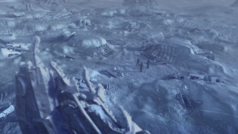
Borg sphere debris in the Arctic Circle
The Arctic Circle or Arctic was a line of latitude north of the equator on Earth, which marked the boundary between the North Pole and regions south of the circle. It passed through the continents of Asia, Europe, and North America.
In the late 17th century, the Arctic Circle, located under the Kara Sea, was labeled on a map of Earth. The label for this latitude was in Latin - "Circulus Arcticus". (Star Trek: Enterprise opening credits)
In 2063, the USS Enterprise-E pursued a Borg sphere to Earth from the 24th century through a Borg-created temporal vortex. The Borg had arrived to destroy the Phoenix, Zefram Cochrane's historic first warp-powered vessel. The Enterprise-E easily destroyed the sphere, though the Borg drones escaped. (Star Trek: First Contact)
Unknown to the Enterprise-E crew, much of the debris from the Borg sphere landed in the Arctic Circle. Nearly a hundred years later, an Earth Sciences Institute team discovered the debris field and recovered two Borg drones from beneath a glacier. The drones thawed and assimilated the researchers and their ship. (ENT: "Regeneration")
Background info
The 17th century map, known as "Harmonia macrocosmica seu atlas universalis et novus, totius universi creati cosmographiam generalem, et novam exhibens", was created by Andreas Cellarius. A scan of the original can be found here.
According to a 21st century-era political map of Earth, seen in the remastered "The Cage", the Arctic Circle was 66° 33ʹ north of the equator. This was a Central Intelligence Agency map published either in April 2007 [1] or September 2008. [2] The difference, which was not noticeable at the resolution of the image from the episode, was the addition of Kosovo, which gained its independence between the releases. The label "Arctic Circle" was illegible to the viewer.
It was possible that the Arctic Circle was on two 20th century-era political maps of Earth used in the original "The Cage". However, due to the poor quality of the images and the inability to identity and access the source material for verification, this was far from certain.
")
")
")